Karioitahi Beach Tide Times & Bite Times Today

Updated Fri, 9 Oct 2026 from LINZ tide predictions and the weather forecast

A west-coast surf beach south of the Manukau Heads, reached by permit-only beach driving and closed to set netting.

3/5
Fair. Fish the windows.A steady pattern: dawn and dusk carry the day.
Next tide
High 10:00 am LINZ
Air / High
12 °C / 19 °C
Wind
E 14 km/h

Sources: LINZ tide predictions, Open-Meteo, solunar calculated for these coordinates.

Satellite view

Karioitahi Beach tide times for the next 7 days

High and low tides in New Zealand time, calculated from LINZ's prediction for Port Taranaki, its standard port, with the differences LINZ publishes for Port Waikato (13.2 km from Karioitahi Beach). Next: high tide at 10:00 am.

DayHigh tideLow tide
Fri 9 Oct (today)10:00 am (2.2 m) · 10:16 pm (2.2 m)4:26 am (0.2 m) · 4:47 pm (0.2 m)
Sat 10 Oct10:40 am (2.2 m) · 10:54 pm (2.3 m)5:08 am (0.1 m) · 5:27 pm (0.1 m)
Sun 11 Oct11:17 am (2.2 m) · 11:30 pm (2.2 m)5:47 am (0.1 m) · 6:04 pm (0.1 m)
Mon 12 Oct11:51 am (2.2 m)6:24 am (0.1 m) · 6:40 pm (0.2 m)
Tue 13 Oct12:04 am (2.2 m) · 12:24 pm (2.2 m)6:59 am (0.2 m) · 7:15 pm (0.3 m)
Wed 14 Oct12:38 am (2.1 m) · 12:58 pm (2.1 m)7:33 am (0.3 m) · 7:50 pm (0.4 m)
Thu 15 Oct1:13 am (2.0 m) · 1:33 pm (2.0 m)8:08 am (0.3 m) · 8:28 pm (0.5 m)

Times and heights follow LINZ's method for secondary ports (the standard port's prediction plus the published mean differences and range ratio); checked against LINZ's own daily prediction for Raglan over a week on 7 October 2026, the method came within 13 minutes and 0.2 m. Heights are above chart datum. These are LINZ predictions, not the official tide tables for navigation, and wind and air pressure can move the real tide by tens of minutes.

Today's Fishing Report

Karioitahi Beach is in its cooler-water pattern: slower baits and the turn of the tide. Today brings clear skies, wind E around 14 km/h, falling pressure near 1024 hPa and a high of 19 °C. Tides: high 10:00 am and 10:16 pm, low 4:26 am and 4:47 pm: the moving water either side of each change is when this place feeds. Water sits around 15 °C for the season (estimated). With the waning crescent, the solunar majors run 11:23 PM-1:23 AM and 10:59 AM-12:59 PM: the windows to build the day around.

Snapper

Good

In spring the schools bunch up before moving onto their spawning grounds; in autumn and winter they spread into deeper, more open water. Either way, fish the 15 to 60 metre marks with baits on the bottom and time the session around the tide change.

Kahawai

Good

Schools are harder to find, so go to them: river mouths and harbour channels at the turn of the tide, with a strip of fresh bait under a float or a soft bait retrieved slowly.

Red gurnard

Good

Fish slower as the water cools: an anchored ledger rig in harbour channels or on the sand off the beaches, with fresh bait.

Trevally

Good

Bottom feeding is the likeliest bite: harbour channels and reef edges, small baits in a steady berley trail, through the tide change.

Kingfish

Good

Fewer people chase kingfish in the cooler months. Deep pinnacles and offshore reef are where to look, with jigs or live bait worked through the tide change.

Flounder

Good

Fish the deeper harbour channels at low water and the flats as the tide comes back in.

Tie on: Two-hook ledger, fresh bait · Slow jig worked close to the bottom · Flasher rig, slow drift · Strip of kahawai or mullet. Prime windows: 11:23 PM-1:23 AM, 10:59 AM-12:59 PM, 5:19 AM-6:19 AM. Similar at 19 °C with likely rain: fish ahead of the front. The solunar majors shift about 50 minutes later.

Fishing times for Karioitahi Beach today

Hour-by-hour bite forecast for today from sunrise (06:46), sunset (19:32), the moon and today's score, with the tide times above. Tap a bar to see why.

Bite planner

Solunar majors 11:23 PM-1:23 AM and 10:59 AM-12:59 PM; minor 5:19 AM-6:19 AM. Waning Crescent, 4% lit.

5 AM8 AM11 AM2 PM5 PM8 PMsunrisesunsetPRIMEPRIME

The moon phase here is astronomy, not a maramataka: what the maramataka is, and why this site does not rate days by it.

Water and weather

Today's tides from LINZ and the forecast for the day, which is a model.

Tide times (LINZ)

Calculated from LINZ's prediction for Port Taranaki, its standard port, with the differences LINZ publishes for Port Waikato (13.2 km from Karioitahi Beach). Heights above chart datum. Fish the moving water either side of each change.

Fri
LOW4:26 am0.19 m
HIGH10:00 am2.16 m
LOW4:47 pm0.19 m
HIGH10:16 pm2.23 m
Sat
LOW5:08 am0.12 m
HIGH10:40 am2.23 m
LOW5:27 pm0.12 m
HIGH10:54 pm2.29 m

Right now

Latest readings

Air temp12 °C
High / Low19 °C / 12 °C
WindE 14 km/h, gusts 22 km/h
Pressure1024.4 hPa, falling
Sky / Rain10% cloud, 67%
Sunrise / Sunset06:46 / 19:32
MoonWaning Crescent, 4%
Water temp (seasonal)~15 °C est.

7-day fishing forecast: which day to fish Karioitahi Beach

The best day on Karioitahi Beach this week looks like Tuesday 13 Oct, at 4 out of 5, against 3 today.

Best day this week: Tuesday, 13 Oct — good at 4/5, falling pressure, usually the best window of a week.

Today, 9 Oct — Fair

A steady pattern: dawn and dusk carry the day.

Solunar majors
11:23 PM-1:23 AM and 10:59 AM-12:59 PM
Minor period
5:19 AM-6:19 AM
Sun
06:46 to 19:32
Moon
Waning Crescent, 4% lit
Sky and wind
Storms, 19 km/h
Rain chance
67%

Forecast-based scores, less reliable further out.

Species guide

The species that matter on Karioitahi Beach: seasons written for the southern year, and how to fish each one. Today's ratings live in the report above.

Snapper

Year-round; spawning schools gather in November and December, and winter fish sit deeper

Tāmure or kouarea in te reo Māori. MPI describes snapper as the dominant fish of northern inshore waters, most common where the sea is warmer and especially in the Hauraki Gulf, at home on reef as well as sand and mud, usually between 15 and 60 metres. The Fisheries Assessment Plenary calls it the largest recreational fishery in New Zealand. In spring the schools bunch up before moving onto their spawning grounds; in autumn and winter they spread into deeper, more open water. Either way, fish the 15 to 60 metre marks with baits on the bottom and time the session around the tide change.

Kahawai

Year-round on every coast; most fishing trips happen in summer

Kahawai (Arripis trutta) live right around New Zealand in coastal seas, harbours and estuaries, and run into the brackish lower reaches of rivers. A schooling fish that takes bait readily and eats mostly small fish and krill; MPI notes a second species, the Kermadec kahawai, which turns up seasonally around Northland. The Plenary records kahawai as an important customary food fish for Māori. Schools are harder to find, so go to them: river mouths and harbour channels at the turn of the tide, with a strip of fresh bait under a float or a soft bait retrieved slowly.

Red gurnard

Year-round; spawning through spring and summer, peaking in early summer

Kumukumu in te reo Māori. Red gurnard live across harbours and shallow coastal waters, which the Plenary says makes them an important recreational species, often caught by people fishing for snapper and tarakihi. They spawn through spring and summer, and small juveniles shelter in shallow harbours. Fish slower as the water cools: an anchored ledger rig in harbour channels or on the sand off the beaches, with fresh bait.

Trevally

Year-round, mainly in the north; surface schools show in calm, settled weather

Araara in te reo Māori. Trevally feed both at the surface and on the bottom: schools appear on top, in midwater and over the seabed, often around reef and rough ground and sometimes mixed with kōheru and kahawai. Young fish live in estuaries and harbours. The Plenary notes that surface schools come with settled weather rather than at a set time of year, and that trevally can live beyond 40 years. Bottom feeding is the likeliest bite: harbour channels and reef edges, small baits in a steady berley trail, through the tide change.

Kingfish

Year-round in the north, with most trips in summer; MPI sets a 75 cm minimum length

Haku or kahu in te reo Māori. MPI says kingfish are most common in the northern half of the North Island but range from the Kermadec Islands to Foveaux Strait, around reefs, pinnacles and rocky outcrops with strong current or tidal flow. Adults grow past 1.5 metres, and MPI puts the average recreational fish at about 10 kg. The Plenary notes that a high share of the recreational catch is released. Fewer people chase kingfish in the cooler months. Deep pinnacles and offshore reef are where to look, with jigs or live bait worked through the tide change.

Flounder

Year-round in harbours and estuaries; young adults move offshore to spawn in winter and spring

Pātiki in te reo Māori. Four flounder species make up most of the recreational flatfish catch, taken in harbours, estuaries, coastal lakes and inlets around the country (Plenary). Most are netted or speared from the shore rather than caught on a line. Flatfish stay in water shallower than about 50 metres, and juveniles grow up on sheltered mud and sand flats. Fish the deeper harbour channels at low water and the flats as the tide comes back in.

Fishing rules at Karioitahi Beach: MPI Auckland and Kermadec area

You do not need a licence to fish in the sea around New Zealand, but the Ministry for Primary Industries (MPI) sets daily limits, minimum sizes and closures for each area, and Karioitahi Beach is in the Auckland and Kermadec area. The figures below are per person per day, as MPI's area page printed them on 7 October 2026. Fishing in rivers and lakes needs a licence: New Zealand fishing licence.

FishWhere it appliesDaily limitMinimum length
All finfish combinedAuckland and Kermadec area, excluding baitfish (50 combined) and freshwater eels (6)20—
SnapperAuckland East (SNA1: North Cape to Cape Runaway)730 cm
SnapperAuckland West (North Cape to Tirua Point)1027 cm
SnapperRow labelled "Auckland/Kermadecs" (read as the Kermadecs)1527 cm
KahawaiAuckland and Kermadec areaIn the combined limitNone set
KingfishAuckland375 cm
KingfishKermadecs; Kermadecs: groper/bass and kingfish 5 combined, no more than 3 kingfishIn the combined limit75 cm
TrevallyAuckland and Kermadec areaIn the combined limit25 cm
GurnardAuckland and Kermadec areaIn the combined limit25 cm
TarakihiAuckland and Kermadec areaIn the combined limit25 cm
Blue codAuckland and Kermadec area; landed whole or gutted; accumulation of 2 daily limits on multi-day trips with proofIn the combined limit30 cm
Red codAuckland and Kermadec areaIn the combined limit25 cm
FlounderAuckland and Kermadec areaIn the combined limitNone set
John DoryAuckland and Kermadec area; not listed; falls under "all other finfish"In the combined limitNone set
ShellfishWhere it appliesDaily limitMinimum size
ScallopsAuckland and Kermadec area; season 1 Sep to 31 Mar20100 mm
CocklesAuckland and Kermadec150None set
CocklesAuckland Coromandel area50None set
Pāua (blackfoot)Auckland and Kermadec area10125 mm
Pāua (yellowfoot)Auckland and Kermadec area1080 mm
Rock lobster (crayfish)CRA 1, "Kaipara Harbour North Head and Te Arai Point"2 spiny, 3 packhorseTail width spiny 54 mm male, 60 mm female; packhorse 84 mm male, 90 mm female
Rock lobster (crayfish)CRA 2, Te Arai Point to East Cape3 spiny, 3 packhorseTail width spiny 54 mm male, 60 mm female; packhorse 84 mm male, 90 mm female
Rock lobster (crayfish)West coast south of Kaipara Harbour6 (no more than 3 packhorse)Tail width spiny 54 mm male, 60 mm female; packhorse 84 mm male, 90 mm female

Rules change often, sometimes at short notice: check MPI's Auckland and Kermadec fishing rules or the NZ Fishing Rules app before you keep any fish. Source: Ministry for Primary Industries and licensed by MPI for re-use under the Creative Commons Attribution 4.0 International licence.

When to come: the Karioitahi Beach calendar

Activity by species and month for the southern year, and how the water warms and cools. Tap any cell.

Species activity by month

1 = slow, 5 = peak. Current month highlighted. January is midsummer here.

J
F
M
A
M
J
J
A
S
O
N
D
Snapper
Kahawai
Red gurnard
Trevally
Kingfish
Flounder
SlowPeak

Water temperature through the year

Typical surface temperature for this water type in degrees Celsius; today is around 15 °C (estimated, not a reading).

1020JanMarMayJulSepNovOct, ~15 F now

Angler reports

Real reports from real anglers, reviewed before publishing. Nothing here is copied from a shop or a charter. The water log below tracks each day automatically.

No angler reports yetBe the first: your report helps every angler who checks Karioitahi Beach today.

Water log, last days

Auto-logged from live data
Thu, Oct 8

4/5 Good. Solid day ahead. Stable-to-falling pressure and workable wind line things up. Snapper led the card at excellent. High of 17 °C, wind to 16 km/h.

Wed, Oct 7

3/5 Fair. Fish the windows. A steady pattern: dawn and dusk carry the day. Snapper led the card at good. High of 16 °C, wind to 16 km/h.

Tue, Oct 6

4/5 Good. Solid day ahead. Stable-to-falling pressure and workable wind line things up. Snapper led the card at excellent. High of 17 °C, wind to 16 km/h.

Where roughly, what depth, what bait. Skip anything you want to keep secret.
Only used to send you this water's report each week. No spam, ever.

Before you go

Licence

No licence is needed to fish the sea around New Zealand (MPI). Rivers and lakes need a licence: New Zealand fishing licence.

Regulations

Daily limits, minimum sizes and closures are set by MPI for each area and change often: the rules for Karioitahi Beach are above, with the date they were read and the link to check them before you keep anything.

Access

undefined.

About this water

Karioitahi Beach is a bay or coastal water in Auckland, New Zealand, covered from the Auckland reports and listed in all New Zealand waters.

Fishing Karioitahi Beach: the full guide

Getting onto the beach

Karioitahi is one of the two Auckland beaches where Auckland Council allows driving, and only with a beach driving permit that must be renewed each year. Vehicles may use the beach only within three hours either side of low tide and must keep to the hard sand below the high-tide line. The limit is 20 km/h from 1,000 m north to 1,000 m south of the Karioitahi Road access, and 60 km/h beyond.

Rules

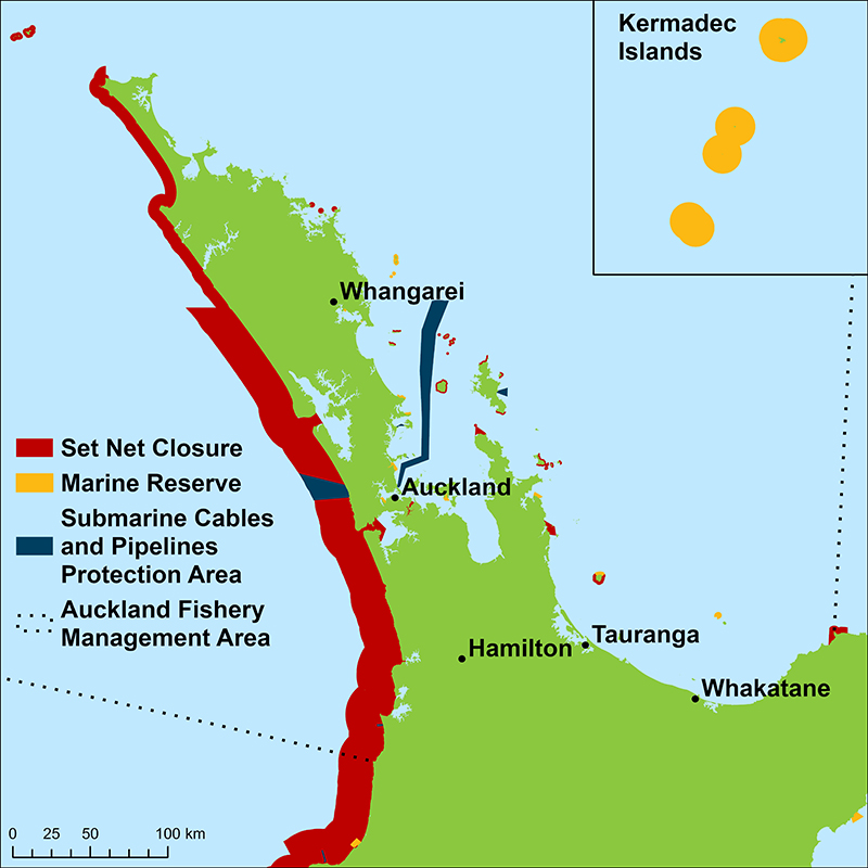
MPI’s west coast set-net closure, from Pariokariwa Point to Maunganui Bluff, takes in Karioitahi. Auckland Council lists no boat ramp on this coast.

Common questions

Can I drive on Karioitahi Beach to fish?

You can if you hold an Auckland Council beach driving permit, renewed each year, and only within three hours either side of low tide.

Can I set net at Karioitahi Beach?

Set netting is not allowed: Karioitahi falls inside MPI’s west coast closure.

Where do the tide times for Karioitahi Beach come from?

They are calculated from LINZ’s prediction for Port Taranaki with the time differences LINZ publishes for Port Waikato, 13.2 km away, using LINZ’s own method.

Is fishing good at Karioitahi Beach right now?

Check the daily report at the top of this page: it is regenerated every morning from live data. Today's read: Fair. Fish the windows. A steady pattern: dawn and dusk carry the day.

Nearby places

Where this page's numbers come from

Tide times
Toitū Te Whenua Land Information New Zealand (LINZ), tide predictions for Port Taranaki (standard port) and Port Waikato (secondary port)
This work is based on Toitū Te Whenua Land Information New Zealand data which are licensed by Toitū Te Whenua Land Information New Zealand for re-use under the Creative Commons Attribution 4.0 International licence. Secondary-port times and heights calculated on this site with the method and the differences LINZ publishes in the New Zealand Nautical Almanac 2026–27. Not the official tide tables for navigation (Maritime Rules Part 25).
Open-Meteo forecast model
https://open-meteo.com/
Queried at -37.2827, 174.6543 in this water's own timezone. A model, not an observation.
Moon and solunar windows
Calculated on this site
Astronomical calculation from these coordinates and the date, not a third-party feed.
Pages checked
The facts in the written guide below were checked against these pages, mostly from the agencies, water authorities, park services and councils that manage the water, on 7 October 2026. Anything we could not verify was taken out.
The written guide on this page
Pablo Ruiz Quintero
How this page was made. The daily report is computed by our scoring engine from live readings; nobody types it. The written text was drafted with AI assistance from the official pages listed above, and its facts were checked against those pages by automated verification on 7 October 2026; anything that could not be verified was taken out. Pablo Ruiz Quintero sets every guideline, the data-verification system and the minimum standards a page must meet to be published, reviews page structure and approves what goes live; the responsibility is his, and the AI carries out the work. We work this way because it is how one person can keep every page current with named sources. Not yet reviewed by a New Zealand angler or editor. Errors are published in the verification log; the full policy is in the editorial policy.

The forecast refreshes on a 30-minute window; tide predictions are LINZ’s for the year. The full method, with every figure and its source, is on How our reports are made. Something wrong here? Tell us and it goes in the log with the date.

Share your catch