Blue cod
Good
The spawning season runs through late winter and spring: fish reef and gravel patches with cut bait on a large hook.
Updated Fri, 9 Oct 2026 from LINZ tide predictions and the weather forecast
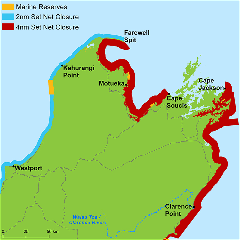
Eastern Marlborough’s Wairau Bar locality, with LINZ’s Wairau River Entrance tide station about 2 km away and a 4-nautical-mile set-net ban along the coast.
Sources: LINZ tide predictions, Open-Meteo, solunar calculated for these coordinates.
High and low tides in New Zealand time, calculated from LINZ's prediction for Wellington, its standard port, with the differences LINZ publishes for Wairau River Entrance (2.2 km from Wairau Bar). Next: low tide at 11:26 am.
| Day | High tide | Low tide |
|---|---|---|
| Fri 9 Oct (today) | 5:14 am (1.6 m) · 5:40 pm (1.6 m) | 11:26 am (0.6 m) · 11:50 pm (0.7 m) |
| Sat 10 Oct | 6:10 am (1.6 m) · 6:35 pm (1.6 m) | 12:23 pm (0.6 m) |
| Sun 11 Oct | 7:05 am (1.6 m) · 7:30 pm (1.6 m) | 12:47 am (0.7 m) · 1:21 pm (0.7 m) |
| Mon 12 Oct | 7:58 am (1.6 m) · 8:23 pm (1.6 m) | 1:42 am (0.7 m) · 2:17 pm (0.7 m) |
| Tue 13 Oct | 8:50 am (1.6 m) · 9:15 pm (1.6 m) | 2:36 am (0.7 m) · 3:11 pm (0.7 m) |
| Wed 14 Oct | 9:39 am (1.6 m) · 10:05 pm (1.6 m) | 3:26 am (0.7 m) · 4:03 pm (0.7 m) |
| Thu 15 Oct | 10:27 am (1.6 m) · 10:52 pm (1.6 m) | 4:13 am (0.7 m) · 4:52 pm (0.7 m) |
Times and heights follow LINZ's method for secondary ports (the standard port's prediction plus the published mean differences and range ratio); checked against LINZ's own daily prediction for Raglan over a week on 7 October 2026, the method came within 13 minutes and 0.2 m. Heights are above chart datum. These are LINZ predictions, not the official tide tables for navigation, and wind and air pressure can move the real tide by tens of minutes.
Wairau Bar is in its cooler-water pattern: slower baits and the turn of the tide. Today brings cloud cover, wind SE around 14 km/h, rising pressure near 1028 hPa and a high of 15 °C. Tides: high 5:14 am and 5:40 pm, low 11:26 am and 11:50 pm: the moving water either side of each change is when this place feeds. Water sits around 13 °C for the season (estimated). With the waning crescent, the solunar majors run 11:26 PM-1:26 AM and 11:02 AM-1:02 PM: the windows to build the day around.
The spawning season runs through late winter and spring: fish reef and gravel patches with cut bait on a large hook.
Schools are harder to find, so go to them: river mouths and harbour channels at the turn of the tide, with a strip of fresh bait under a float or a soft bait retrieved slowly.
Anchor or hold over the deeper reef edges with small baits close to the bottom, and move when a mark goes quiet.
Fish slower as the water cools: an anchored ledger rig in harbour channels or on the sand off the beaches, with fresh bait.
In spring the schools bunch up before moving onto their spawning grounds; in autumn and winter they spread into deeper, more open water. Either way, fish the 15 to 60 metre marks with baits on the bottom and time the session around the tide change.
Drop to the bottom over reef and foul ground with cut bait, holding position over the rough patches.
Tie on: Two-hook ledger, fresh bait · Slow jig worked close to the bottom · Flasher rig, slow drift · Strip of kahawai or mullet. Prime windows: 11:26 PM-1:26 AM, 11:02 AM-1:02 PM, 5:22 AM-6:22 AM. Warmer at 18 °C with likely rain: fish ahead of the front. The solunar majors shift about 50 minutes later.
Hour-by-hour bite forecast for today from sunrise (06:45), sunset (19:38), the moon and today's score, with the tide times above. Tap a bar to see why.
Solunar majors 11:26 PM-1:26 AM and 11:02 AM-1:02 PM; minor 5:22 AM-6:22 AM. Waning Crescent, 4% lit.
The moon phase here is astronomy, not a maramataka: what the maramataka is, and why this site does not rate days by it.
Today's tides from LINZ and the forecast for the day, which is a model.
Calculated from LINZ's prediction for Wellington, its standard port, with the differences LINZ publishes for Wairau River Entrance (2.2 km from Wairau Bar). Heights above chart datum. Fish the moving water either side of each change.
Latest readings
The best day on Wairau Bar this week looks like Wednesday 14 Oct, at 4 out of 5, against 3 today.
Best day this week: Wednesday, 14 Oct — good at 4/5, falling pressure, usually the best window of a week.
A steady pattern: dawn and dusk carry the day.
Forecast-based scores, less reliable further out.
The species that matter on Wairau Bar: seasons written for the southern year, and how to fish each one. Today's ratings live in the report above.
Rāwaru or pākirikiri in te reo Māori. A bottom fish found only in New Zealand, living near rough ground to 150 metres and more common south of Cook Strait. The Plenary rates it the most important recreational finfish in Marlborough, Canterbury, Otago and Southland. Blue cod can change sex from female to male, and males grow larger. The spawning season runs through late winter and spring: fish reef and gravel patches with cut bait on a large hook.
Kahawai (Arripis trutta) live right around New Zealand in coastal seas, harbours and estuaries, and run into the brackish lower reaches of rivers. A schooling fish that takes bait readily and eats mostly small fish and krill; MPI notes a second species, the Kermadec kahawai, which turns up seasonally around Northland. The Plenary records kahawai as an important customary food fish for Māori. Schools are harder to find, so go to them: river mouths and harbour channels at the turn of the tide, with a strip of fresh bait under a float or a soft bait retrieved slowly.
Tarakihi are mostly taken on lines, often by people fishing for snapper or blue cod (Plenary). Juveniles grow up in shallow inshore nurseries such as Tasman Bay, the Kaikōura coast, northern Pegasus Bay, the Canterbury Bight and Otago, then move out to 50 to 200 metres at about 25 cm. The minimum fork length is 25 cm in every area. Anchor or hold over the deeper reef edges with small baits close to the bottom, and move when a mark goes quiet.
Kumukumu in te reo Māori. Red gurnard live across harbours and shallow coastal waters, which the Plenary says makes them an important recreational species, often caught by people fishing for snapper and tarakihi. They spawn through spring and summer, and small juveniles shelter in shallow harbours. Fish slower as the water cools: an anchored ledger rig in harbour channels or on the sand off the beaches, with fresh bait.
Tāmure or kouarea in te reo Māori. MPI describes snapper as the dominant fish of northern inshore waters, most common where the sea is warmer and especially in the Hauraki Gulf, at home on reef as well as sand and mud, usually between 15 and 60 metres. The Fisheries Assessment Plenary calls it the largest recreational fishery in New Zealand. In spring the schools bunch up before moving onto their spawning grounds; in autumn and winter they spread into deeper, more open water. Either way, fish the 15 to 60 metre marks with baits on the bottom and time the session around the tide change.
Pōhuiakaroa in te reo Māori. The Plenary says sea perch are seldom targeted but widely caught, almost all on rod and reel from boats, and are now more often kept as an eating fish. The 2022–23 national survey placed most of the recreational harvest off the east coast of the South Island. The inshore species lives on or near the seafloor, mostly shallower than 250 metres. Drop to the bottom over reef and foul ground with cut bait, holding position over the rough patches.
Pātiki in te reo Māori. Four flounder species make up most of the recreational flatfish catch, taken in harbours, estuaries, coastal lakes and inlets around the country (Plenary). Most are netted or speared from the shore rather than caught on a line. Flatfish stay in water shallower than about 50 metres, and juveniles grow up on sheltered mud and sand flats. Fish the deeper harbour channels at low water and the flats as the tide comes back in.
You do not need a licence to fish in the sea around New Zealand, but the Ministry for Primary Industries (MPI) sets daily limits, minimum sizes and closures for each area, and Wairau Bar is in the Challenger area. The figures below are per person per day, as MPI's area page printed them on 7 October 2026. Fishing in rivers and lakes needs a licence: New Zealand fishing licence.
Near an area or zone boundary. Outside the Marlborough Sounds area (Tory Channel–French Pass line), outside SCA 7 (south of West Head) and north of Marfells Beach, so none of those closures apply; still Challenger Tasman blue cod (2 a day).
| Fish | Where it applies | Daily limit | Minimum length |
|---|---|---|---|
| All finfish combined | Challenger area, excluding baitfish (50) and eels (6) | 20 | — |
| Snapper | Challenger | 10 | 25 cm |
| Snapper | Marlborough Sounds area | 3 | 25 cm |
| Kahawai | Challenger area | In the combined limit | None set |
| Kingfish | Challenger area | 3 | 75 cm |
| Trevally | Challenger area | In the combined limit | 25 cm |
| Gurnard | Challenger area | In the combined limit | 25 cm |
| Tarakihi | Challenger area | In the combined limit | 25 cm |
| Blue cod | Tasman: Farewell Spit to Clarence River incl. Marlborough Sounds; whole or gutted; possession up to 4 when entering from outside with proof | 2 | 33 cm |
| Blue cod | Kahurangi: Heaphy River to Farewell Spit | 10 | 33 cm |
| Blue cod | Westland: south bank of Haast River to Heaphy River; headed and gutted allowed, 24 cm headed | 15 | 33 cm |
| Blue cod | South West: Sandhill Point to south bank of Haast River | 10 | 33 cm |
| Red cod | Challenger area | In the combined limit | 25 cm |
| Flounder | Challenger area; flatfish 25 cm; no separate sand flounder row | In the combined limit | 25 cm |
| John Dory | Challenger area; not listed; "all other finfish" | In the combined limit | None set |
| Shellfish | Where it applies | Daily limit | Minimum size |
|---|---|---|---|
| Scallops | Challenger area; season 15 Jul to 14 Feb | 50 | 90 mm |
| Cockles | Challenger area | 150 | None set |
| Pāua (blackfoot) | Tasman, Nelson and Marlborough | 5 | 125 mm |
| Pāua (yellowfoot) | Tasman, Nelson and Marlborough | 5 | 80 mm |
| Pāua (blackfoot) | All other Challenger areas | 10 | 125 mm |
| Pāua (yellowfoot) | All other Challenger areas | 10 | 80 mm |
| Pāua (blackfoot) | Marfells Beach to Conway River (season 1 May–31 Aug) | 3 | 130 mm |
| Pāua (yellowfoot) | Marfells Beach to Conway River (season 1 May–31 Aug) | 3 | 80 mm |
| Rock lobster (crayfish) | Challenger | 6 (no more than 3 packhorse) | Tail width spiny 54 mm male, 60 mm female; packhorse 84 mm male, 90 mm female |
Rules change often, sometimes at short notice: check MPI's Challenger fishing rules or the NZ Fishing Rules app before you keep any fish. Source: Ministry for Primary Industries and licensed by MPI for re-use under the Creative Commons Attribution 4.0 International licence.
Activity by species and month for the southern year, and how the water warms and cools. Tap any cell.
1 = slow, 5 = peak. Current month highlighted. January is midsummer here.
Typical surface temperature for this water type in degrees Celsius; today is around 13 °C (estimated, not a reading).
Real reports from real anglers, reviewed before publishing. Nothing here is copied from a shop or a charter. The water log below tracks each day automatically.
3/5 Fair. Fish the windows. A steady pattern: dawn and dusk carry the day. Blue cod led the card at good. High of 16 °C, wind to 39 km/h.
4/5 Good. Solid day ahead. Stable-to-falling pressure and workable wind line things up. Blue cod led the card at excellent. High of 19 °C, wind to 31 km/h.
4/5 Good. Solid day ahead. Stable-to-falling pressure and workable wind line things up. Blue cod led the card at excellent. High of 18 °C, wind to 32 km/h.
No licence is needed to fish the sea around New Zealand (MPI). Rivers and lakes need a licence: New Zealand fishing licence.
Daily limits, minimum sizes and closures are set by MPI for each area and change often: the rules for Wairau Bar are above, with the date they were read and the link to check them before you keep anything.
undefined.
Wairau Bar is a bay or coastal water in Marlborough, New Zealand, covered from the Marlborough reports and listed in all New Zealand waters.
DOC’s Wairau Lagoons Walkway starts at the end of Hardings Road, which leaves State Highway 1 about 5 km south of Blenheim, and follows the lagoon shore to the main channel. DOC explains that the lagoons built up over some 6,500 years behind an 8 km boulder bank, and that the tide flushes in and out of them every day. In the channel lies the hulk of the Waverley, towed to the Wairau River mouth to be sunk as a breakwater but swept upstream by a flood first.
MPI bans set netting out to 4 nautical miles from Cape Jackson to the Clarence River, and names Te Koko-o-Kupe / Cloudy Bay, Clifford Bay and Cape Campbell in that rule. Its Challenger map draws the band without a break down the east Marlborough coast.
LINZ calculates the Wairau River Entrance from Wellington, with high water about 1 hour 10 minutes after Wellington on average and the same range ratio.
MPI prohibits set netting within 4 nautical miles of shore from Cape Jackson to the Clarence River, a stretch that includes Cloudy Bay, Clifford Bay and Cape Campbell.
From LINZ’s Wairau River Entrance secondary port, about 2 km from the Gazetteer point, corrected from Wellington’s predictions.
They are calculated from LINZ’s prediction for Wellington with the time differences LINZ publishes for Wairau River Entrance, 2.2 km away, using LINZ’s own method.
Check the daily report at the top of this page: it is regenerated every morning from live data. Today's read: Fair. Fish the windows. A steady pattern: dawn and dusk carry the day.
 Pablo Ruiz Quintero
The forecast refreshes on a 30-minute window; tide predictions are LINZ’s for the year. The full method, with every figure and its source, is on How our reports are made. Something wrong here? Tell us and it goes in the log with the date.