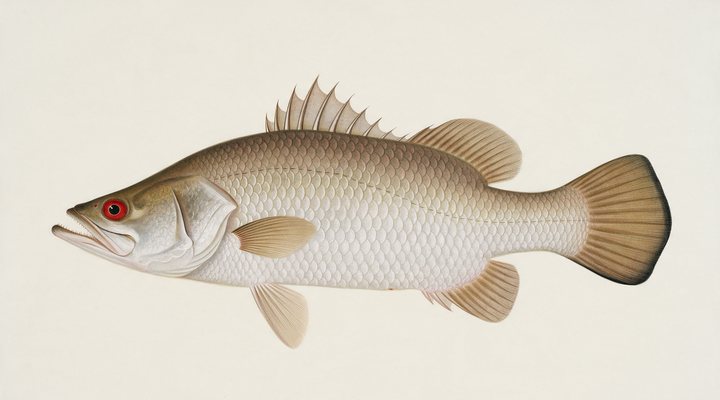
Barramundi
Excellent
Dawn, dusk and the run-off drains and creek mouths on the falling tide; hardbodies and soft vibes cast tight to snags and rock bars.
Updated Mon, 9 Nov 2026 from live weather and tide data
The McArthur River and the Gulf: Borroloola’s barra, the river’s rocky bars, King Ash Bay and the Sir Edward Pellew islands, with the run-off season and the Gulf’s reef.
Sources: Open-Meteo, solunar calculated for these coordinates.
Borroloola is a dawn-and-dusk fishery today, with the middle of the day for moving spots. Today brings cloud cover, wind NE around 5 km/h, rising pressure near 1010 hPa and a high of 39 °C. Water sits around 29 °C for the season (estimated). With the new moon, the solunar majors run 11:24 PM-1:24 AM and 10:60 AM-12:60 PM: plan around them and beat the heat.
Dawn, dusk and the run-off drains and creek mouths on the falling tide; hardbodies and soft vibes cast tight to snags and rock bars.
Troll rigged garfish or lures over the reef edges and shoals at first light; float-line a live bait through the middle of the day.
Tie on: Soft plastic, 3 to 5 inch paddle tail · Pilchard on ganged hooks · Metal slug, 20 to 40 g · Surface walker at first light. Prime windows: 11:24 PM-1:24 AM, 10:60 AM-12:60 PM, 4:54 AM-5:54 AM. Similar at 38 °C with a rain chance. The solunar majors shift about 50 minutes later.
Northern Territory has no general fishing licence, but rules and permits apply. Northern Territory fishing licence: cost, rules and where to buy →
Chasing barramundi here? Check the size and bag limits with NT Fisheries before you keep anything; the Barramundi page has the seasons and the tactics.
Hour-by-hour bite forecast for today from sunrise (05:45), sunset (18:32), the moon and today's score. Tap a bar to see why.
Solunar majors 11:24 PM-1:24 AM and 10:60 AM-12:60 PM; minor 4:54 AM-5:54 AM. New Moon, 0% lit.
Conditions here are modelled from weather, season and the nearest stations.
Water readings appear when a Bureau of Meteorology station covers it. Until then the seasonal curve below is the estimate.
Latest readings
The best day on Borroloola this week looks like Sunday 15 Nov, at 3 out of 5, against 2 today.
Best day this week: Sunday, 15 Nov — fair at 3/5, steady pressure, neither help nor hindrance.
Conditions favor short windows and patient fishing.
Forecast-based scores, less reliable further out.
The species that matter on Borroloola: seasons written for the southern year, and how to fish each one. Today's ratings live in the report above.
The north's fish. Tidal rivers, run-off creeks, rock bars and the stocked impoundments. Warm water, moving water and a barometer on the way down. Dawn, dusk and the run-off drains and creek mouths on the falling tide; hardbodies and soft vibes cast tight to snags and rock bars.
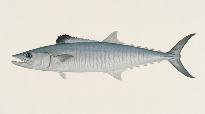
The narrow-barred Spanish mackerel: a speedster of the headlands, reefs and shoals from Queensland around to northern WA, and a summer visitor to NSW. Troll rigged garfish or lures over the reef edges and shoals at first light; float-line a live bait through the middle of the day.
Activity by species and month for the southern year, and how the water warms and cools. Tap any cell.
1 = slow, 5 = peak. Current month highlighted. January is midsummer here.
Typical surface temperature for this water type in degrees Celsius; today is around 29 °C (estimated, not a reading).
Real reports from real anglers, reviewed before publishing. Nothing here is copied from a shop or a charter. The water log below tracks each day automatically.
3/5 Fair. Fish early or late. Heat pins the bite to the dawn and dusk windows. Barramundi led the card at excellent. High of 36 °C, wind to 14 km/h.
2/5 Slow. Work for them. Conditions favor short windows and patient fishing. Barramundi led the card at excellent. High of 38 °C, wind to 19 km/h.
2/5 Slow. Work for them. Conditions favor short windows and patient fishing. Barramundi led the card at excellent. High of 38 °C, wind to 16 km/h.
Northern Territory has no general recreational fishing licence; the limits and closures do. Details and where to buy →
Size and bag limits, closed seasons and marine park zones are set by NT Fisheries and change: confirm the current rules on the agency page linked from the Northern Territory licence page before you keep anything.
The Northern Territory has no recreational fishing licence, at Borroloola or anywhere; the possession and size limits, the black jewfish and golden snapper limits, closed areas and the permits for fishing near Aboriginal land apply, on the NT Government pages linked below.
Borroloola is a coastal town in Northern Territory, Australia, covered from the Northern Territory reports and listed in all Australia waters.
Borroloola is the town on the McArthur River in the Gulf country of the Northern Territory near the Queensland border, with the river running past the town over rocky bars to the tidal reaches, King Ash Bay on the lower river, the mouth at the Gulf of Carpentaria, the Sir Edward Pellew islands off the mouth and the Gulf’s reefs beyond. It is a river town for one fish, and the report on this page is scored for the town’s coordinates. The Roper River at Roper Bar has its own page.
Barramundi fish the McArthur’s bars, the snags and the tidal reaches in the run-off and the build-up and are the reason people drive here; black jewfish and golden snapper fish the islands’ reef for the boats, under the NT’s possession limits; Spanish mackerel run the Pellews in the dry season; queenfish and trevally work the mouth and the islands; threadfin salmon fish the mouth flats; mud crabs work the mangroves under the pot rules; and sooty grunter fish the upper river’s fresh reaches. The NT Government notes that barramundi spawn between September and March, in marine bays and river mouths.
The McArthur at the town, down through the rocky bars, is the barra and sooty grunter water for kayaks and small boats in the run-off, and the tidal reaches from King Ash Bay down to the mouth are barra and threadfin water on the run-out; the Sir Edward Pellew islands off the mouth are the mackerel, jewfish and reef run for the bigger boats. The run to the islands crosses open Gulf water, so it is a trip for settled weather and a boat equipped for it.
The river is sheltered and the Gulf is open to the dry-season south-easterly; the wind row matters for the run to the islands. The tide panel is a modelled curve for the coordinates of Borroloola, labelled as a model, and it rules the lower river and the mouth, with the town reaches above the tide. Pressure and sky build the score at Borroloola, and the rain row matters most, because the run-off after the wet is the barra season and heavy rain can cut the roads in; the planner shows the day.
The Northern Territory has no recreational fishing licence, at Borroloola or anywhere; the possession and size limits, the black jewfish and golden snapper limits, closed areas and the permits for fishing near Aboriginal land apply, on the NT Government pages linked below. Check the NT road report before driving in during or after the wet, and read the NT crocodile safety advice before fishing from any bank here.
The run-off after the wet and the build-up before it are the peak times. The NT has no Territory-wide barramundi closed season, but it does close particular areas, such as the Daly River seasonal closure area from 1 October to 31 January; check the NT rules for specific areas before a trip.
No. There is no recreational fishing licence anywhere in the Northern Territory; at Borroloola the possession limits and the rules for fishing near Aboriginal land still apply.
Check the daily report at the top of this page: it is regenerated every morning from live data. Today's read: Slow. Work for them. Conditions favor short windows and patient fishing.
 Pablo Ruiz Quintero
Readings refresh on a 30-minute window. The full method, with every figure and its source, is on How our reports are made. Something wrong here? Tell us and it goes in the log with the date.