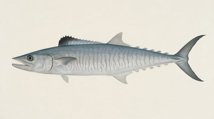
Spanish mackerel
Excellent
Prime. Trolled baits and hardbodies over structure on the tide change, or high-speed metals cast at surface schools.
Updated Sat, 26 Sept 2026 from live weather and tide data
The Pioneer River, the harbour and the islands: a sugar city on the central coast with the reef offshore and barramundi in the creeks.
Sources: modelled tide curve, Open-Meteo, solunar calculated for these coordinates.
Mackay has the water in the comfortable band where most of its fish feed through the day. Today brings clear skies, wind SE around 24 km/h, falling pressure near 1024 hPa and a high of 23 °C. Tides: high 10:01 am and 10:11 pm, low 4:02 am and 4:09 pm: the moving water either side of each change is when this place feeds. Water sits around 26 °C for the season (estimated). With the full moon, the solunar majors run 11:16 PM-1:16 AM and 11:16 AM-1:16 PM: the windows to build the day around.
Prime. Trolled baits and hardbodies over structure on the tide change, or high-speed metals cast at surface schools.
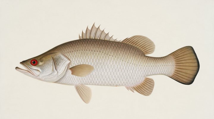
Work the colour changes and the snags on the run-out; larger swimbaits and slow-rolled plastics in the impoundments.
Tie on: Soft plastic on a 1/4 oz jighead · Small hardbody, shallow diver · Squid jig, size 3.0 · Fresh pipi or worm on a small hook. Prime windows: 11:16 PM-1:16 AM, 11:16 AM-1:16 PM, 5:46 AM-6:46 AM. Similar at 23 °C with a rain chance. The solunar majors shift about 50 minutes later.
Queensland has no general fishing licence, but rules and permits apply. Queensland fishing licence: cost, rules and where to buy →
Chasing barramundi here? Check the size and bag limits with Queensland DPI before you keep anything; the Barramundi page has the seasons and the tactics.
Hour-by-hour bite forecast for today from sunrise (05:49), sunset (18:00), the moon and today's score, with the modelled tide changes in the panel below. Tap a bar to see why.
Solunar majors 11:16 PM-1:16 AM and 11:16 AM-1:16 PM; minor 5:46 AM-6:46 AM. Full Moon, 100% lit.
A modelled tide curve for these coordinates and the forecast for the day.
Modelled sea level curve from Open-Meteo Marine for these coordinates, datum mean sea level. Fish the moving water either side of each change.
A model, not the official prediction: times can drift by tens of minutes inside bays and estuaries. Check the Bureau of Meteorology tide predictions for the exact times before you rely on them.
Latest readings
Why the tide matters here: tides and fishing in Australia.
The best day on Mackay this week looks like Tuesday 29 Sept, at 4 out of 5, against 3 today. Every day is scored by the same engine as the report above: pressure trend first, then wind, sky and season. Pick a species and the plan for that day changes with it.
Best day this week: Tuesday, 29 Sept — good at 4/5, steady pressure, neither help nor hindrance.
A steady pattern: dawn and dusk carry the day.
Scores are a planning aid built from forecast data, not a promise.
The species that matter on Mackay: seasons written for the southern year, and how to fish each one. Today's ratings live in the report above.
Open now Closes 1 Nov 2026. Closed 1 November to 31 January on the east coast, tidal and fresh, except in the stocked dams the Queensland Government lists. No catch and release in the closure. Rule as read from Queensland Department of Primary Industries on 2026-09-23.
The north's fish. Tidal rivers, run-off creeks, rock bars and the stocked impoundments. Warm water, moving water and a barometer on the way down. Work the colour changes and the snags on the run-out; larger swimbaits and slow-rolled plastics in the impoundments.
The narrow-barred Spanish mackerel: a speedster of the headlands, reefs and shoals from Queensland around to northern WA, and a summer visitor to NSW. Prime. Trolled baits and hardbodies over structure on the tide change, or high-speed metals cast at surface schools.
Activity by species and month for the southern year, and how the water warms and cools. Tap any cell.
1 = slow, 5 = peak. Current month highlighted. January is midsummer here.
Typical surface temperature for this water type in degrees Celsius; today is around 26 °C (estimated, not a reading).
Real reports from real anglers, reviewed before publishing. Nothing here is copied from a shop or a charter. The water log below tracks each day automatically.
3/5 Fair. Fish the windows. A steady pattern: dawn and dusk carry the day. Spanish mackerel led the card at excellent. High of 23 °C, wind to 29 km/h.
3/5 Fair. Fish the windows. A steady pattern: dawn and dusk carry the day. Spanish mackerel led the card at excellent. High of 24 °C, wind to 29 km/h.
3/5 Fair. Fish the windows. A steady pattern: dawn and dusk carry the day. Spanish mackerel led the card at excellent. High of 24 °C, wind to 27 km/h.
Queensland has no general recreational fishing licence; permits apply on some waters and the limits and closures do. Details and where to buy →
Size and bag limits, closed seasons and marine park zones are set by Queensland DPI and change: confirm the current rules on the agency page linked from the Queensland licence page before you keep anything.
Queensland has no general fishing licence; the barramundi closed season, the coral reef fin fish rules, the size and bag limits and the marine park zoning apply, on the pages linked below.
Mackay is a coastal town in Queensland, Australia, covered from the Queensland reports and listed in all Australia waters.
Mackay is the city of Queensland’s central coast, on the Pioneer River with the harbour and its breakwaters to the north, the creeks and the mangroves either side, and the Whitsunday-side islands and the reef offshore. The fishing is the river and its mouth, the harbour walls and the marina, the beaches from the harbour to Eimeo and Shoal Point, the creeks toward Sarina and Seaforth, and the reef for the boats. It is dry-tropics country, with a wet season that floods the river and a dry that settles the seas. The report on this page is scored for the city’s coordinates.
Barramundi fish the river, the creeks and the harbour on the run-off and the build-up, with the east coast closed season through the summer spawning that the Queensland Government publishes; mangrove jack and grunter fish the creeks and the harbour walls, queenfish and trevally the harbour and the beaches on the tide, and Spanish mackerel run the headlands and the islands in the cooler months. Mud crabs are a pot fishery in the creeks. The reef gives coral trout, nannygai and the reef species under the coral reef fin fish rules for the boats when the trade wind allows.
The south-easterly trade wind is the row to read: it decides whether the islands and the reef are reachable and pushes the fishing into the river and the harbour. Pressure matters for barramundi, a falling barometer before a storm being the classic bite, and the rain row shows the wet arriving. The tide panel is a modelled curve for these coordinates, labelled as a model; Mackay has one of the biggest tides on the east coast, so the direction and the size of the tide decide where the fish are, and the Bureau of Meteorology has the minute. Crocodiles live in the river and the creeks.
Queensland has no general fishing licence; the barramundi closed season, the coral reef fin fish rules, the size and bag limits and the marine park zoning apply, on the pages linked below. The harbour walls, the river banks and the beaches are public, with ramps at the harbour, the river and the creeks.
No. Queensland has no recreational fishing licence; closed seasons, limits and marine park zones apply.
The east coast has a closed season through the summer spawning, published by the Queensland Government; the run-off after the wet and the build-up are the classic times.
Check the daily report at the top of this page: it is regenerated every morning from live data. Today's read: Fair. Fish the windows. A steady pattern: dawn and dusk carry the day.
 Pablo Ruiz Quintero
Readings refresh on a 30-minute window. The full method, with every figure and its source, is on How our reports are made. Something wrong here? Tell us and it goes in the log with the date.