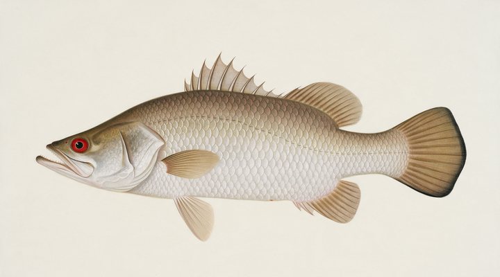
Barramundi
Excellent
Dawn, dusk and the run-off drains and creek mouths on the falling tide; hardbodies and soft vibes cast tight to snags and rock bars.
Updated Mon, 9 Nov 2026 from live weather and tide data
The Gascoyne River mouth and the fascine: Carnarvon’s mulloway, mangrove jack and whiting, the Babbage Island coast and the Shark Bay water to the south.
Sources: modelled tide curve, Open-Meteo, solunar calculated for these coordinates.
Carnarvon is in full summer mode: early starts, shade at midday, and the evening change. Today brings cloud cover, wind S around 27 km/h, steady pressure near 1015 hPa and a high of 26 °C. Tides: high 11:06 am and 9:35 pm, low 4:19 am and 2:54 pm: the moving water either side of each change is when this place feeds. Water sits around 29 °C for the season (estimated). With the new moon, the solunar majors run 11:28 PM-1:28 AM and 11:04 AM-1:04 PM: plan around them and beat the heat.
Dawn, dusk and the run-off drains and creek mouths on the falling tide; hardbodies and soft vibes cast tight to snags and rock bars.
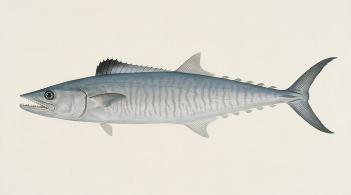
Troll rigged garfish or lures over the reef edges and shoals at first light; float-line a live bait through the middle of the day.
Tie on: Soft plastic, 3 to 5 inch paddle tail · Pilchard on ganged hooks · Metal slug, 20 to 40 g · Surface walker at first light. Prime windows: 11:28 PM-1:28 AM, 11:04 AM-1:04 PM, 4:41 AM-5:41 AM. Similar at 25 °C. The solunar majors shift about 50 minutes later.
Western Australia requires a fishing licence for most fishing, from A$40.00. Western Australia fishing licence: cost, rules and where to buy →
Chasing barramundi here? Check the size and bag limits with DPIRD WA before you keep anything; the Barramundi page has the seasons and the tactics.
Hour-by-hour bite forecast for today from sunrise (05:33), sunset (18:45), the moon and today's score, with the modelled tide changes in the panel below. Tap a bar to see why.
Solunar majors 11:28 PM-1:28 AM and 11:04 AM-1:04 PM; minor 4:41 AM-5:41 AM. New Moon, 0% lit.
A modelled tide curve for these coordinates and the forecast for the day.
Modelled sea level curve from Open-Meteo Marine for these coordinates, datum mean sea level. Fish the moving water either side of each change.
A model, not the official prediction: times can drift by tens of minutes inside bays and estuaries. Check the Bureau of Meteorology tide predictions for the exact times before you rely on them.
Latest readings
Why the tide matters here: tides and fishing in Australia.
The best day on Carnarvon this week looks like Friday 13 Nov, at 4 out of 5, against 3 today.
Best day this week: Friday, 13 Nov — good at 4/5, falling pressure, usually the best window of a week.
Heat pins the bite to the dawn and dusk windows.
Forecast-based scores, less reliable further out.
The species that matter on Carnarvon: seasons written for the southern year, and how to fish each one. Today's ratings live in the report above.
The north's fish. Tidal rivers, run-off creeks, rock bars and the stocked impoundments. Warm water, moving water and a barometer on the way down. Dawn, dusk and the run-off drains and creek mouths on the falling tide; hardbodies and soft vibes cast tight to snags and rock bars.
The narrow-barred Spanish mackerel: a speedster of the headlands, reefs and shoals from Queensland around to northern WA, and a summer visitor to NSW. Troll rigged garfish or lures over the reef edges and shoals at first light; float-line a live bait through the middle of the day.
Activity by species and month for the southern year, and how the water warms and cools. Tap any cell.
1 = slow, 5 = peak. Current month highlighted. January is midsummer here.
Typical surface temperature for this water type in degrees Celsius; today is around 29 °C (estimated, not a reading).
Real reports from real anglers, reviewed before publishing. Nothing here is copied from a shop or a charter. The water log below tracks each day automatically.
3/5 Fair. Fish early or late. Heat pins the bite to the dawn and dusk windows. Barramundi led the card at excellent. High of 26 °C, wind to 32 km/h.
3/5 Fair. Fish early or late. Heat pins the bite to the dawn and dusk windows. Barramundi led the card at excellent. High of 26 °C, wind to 29 km/h.
3/5 Fair. Fish early or late. Heat pins the bite to the dawn and dusk windows. Barramundi led the card at excellent. High of 25 °C, wind to 29 km/h.
Western Australian recreational fishing licences, from A$40.00, the same for residents and visitors. Details and where to buy →
Size and bag limits, closed seasons and marine park zones are set by DPIRD WA and change: confirm the current rules on the agency page linked from the Western Australia licence page before you keep anything.
Line fishing from the shore at Carnarvon is not among Western Australia’s licensed activities; fishing from a powered boat needs the Recreational Fishing from Boat Licence and the crab rules apply; our Western Australia page has the fees.
Carnarvon is a coastal town in Western Australia, Australia, covered from the Western Australia reports and listed in all Australia waters.
Carnarvon is the plantation town at the mouth of the Gascoyne River on the Gascoyne coast, with the fascine and the small boat harbour on the town’s waterfront, the river’s mouth and its mangrove creeks to the north, the heritage One Mile Jetty, closed to the public since 2017, the Pelican Point flats and the Shark Bay water to the south, and open water offshore. It is a river-mouth town on a desert coast, and the report on this page is scored for the town’s coordinates. Exmouth has its own page.
Mulloway fish the river mouth, the fascine and the beaches at night and are the town’s fish; mangrove jack fish the mangrove creeks in the warm season; whiting fish the flats and the beaches all year; bream fish the creeks and the harbour walls; tailor run the beaches in the cooler months; Spanish mackerel run the reef from winter into spring; pink snapper fish the Shark Bay water under DPIRD’s separate rules for its inner-gulf and oceanic stocks; and the offshore grounds give demersal fish for the boats under the Gascoyne limits. Blue swimmer crabs work the flats in the warm months.
The fascine along the town waterfront and the small boat harbour walls are the walk-on marks for bream, whiting and mulloway, fished at night under the lights and on the run-in, and the Gascoyne mouth and the mangrove creeks north of the town toward Miaboolya are the jack, mulloway and crab water for small boats; the beaches around Pelican Point south of the town are the whiting and tailor sand; the One Mile Jetty itself is being partly restored and is not open. The ramps are at the harbour and the river.
The coast faces west and a south-westerly builds the sea and closes the beaches, while the fascine and the creeks stay fishable and the winter easterlies flatten everything; the wind row tells you which. The tide panel is a modelled curve for the coordinates of Carnarvon, labelled as a model, and the flats and the creeks run on it. Pressure and sky build the score at Carnarvon, and the rain row matters because the Gascoyne only runs after cyclone rain inland; the planner shows the day.
Line fishing from the shore at Carnarvon is not among Western Australia’s licensed activities; fishing from a powered boat needs the Recreational Fishing from Boat Licence and the crab rules apply; our Western Australia page has the fees. The fascine, the harbour and the beaches are public, with ramps at the harbour and the river; the Gascoyne demersal rules, the Shark Bay pink snapper rules and the DPIRD limits are in the sources.
Mulloway at the river mouth and the fascine at night, mangrove jack in the creeks in the warm season, whiting on the flats, tailor on the beaches in the cooler months, mackerel on the reef for the boats.
Not from the fascine or the beaches; a powered boat off Carnarvon needs a Recreational Fishing from Boat Licence.
Check the daily report at the top of this page: it is regenerated every morning from live data. Today's read: Fair. Fish early or late. Heat pins the bite to the dawn and dusk windows.
 Pablo Ruiz Quintero
Readings refresh on a 30-minute window. The full method, with every figure and its source, is on How our reports are made. Something wrong here? Tell us and it goes in the log with the date.