White River Fishing Report, Arkansas

Updated Fri, Oct 23, 2026 from live gauge and weather data

The White River below Bull Shoals Dam: a cold tailwater with more than 90 miles of trout water, fished under AGFC's reduced 2026 trout limits.

3/5
Fair. Fish the windows.A steady pattern: dawn and dusk carry the day.
Flow
2,810 cfs
Air / High
78 / 78 F
Wind
SE 4 mph

Sources: USGS gauge 07057370, Open-Meteo, solunar calculated for these coordinates.

Satellite view
Friday
23
October 2026

Today's Fishing Report

Generated this morning from live readings: gauge, weather model, sun and moon. A fresh report is published here every morning.

3/5Fair. Fish the windows.A steady pattern: dawn and dusk carry the day.

White River fishes cold and honest: earn your bites in the deep stuff. The river is running 2,810 cfs, dropping and clearing. Today brings clear skies, wind SE around 4 mph, steady pressure near 1021 hPa and a high of 78. Water sits around 47 F for the season (estimated). With the waxing gibbous, the solunar majors run 9:45 AM-11:45 AM and 10:13 PM-12:13 AM: the windows to build the day around.

The plan, species by species
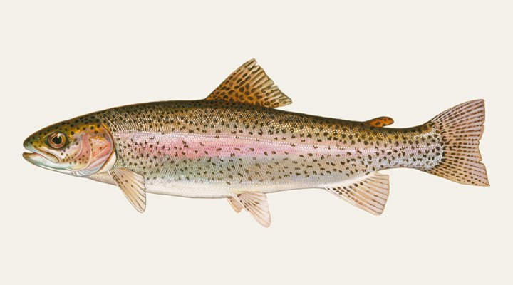
Rainbow troutExcellent

In cold water rainbows use the deepest pools in rivers (Vermont), so slow, deep drifts there are the usual approach; Michigan DNR notes lake rainbows are also taken with bait or by jigging through the ice.
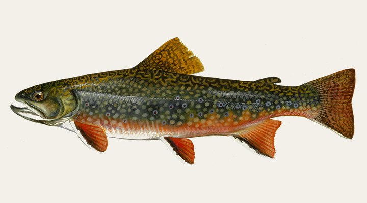
Brook troutExcellent

Below 50°F is the fall spawning band (40-50°F in Vermont), so stay off spawning gravel. In winter Maine IFW finds pond fish close to shore in 4 to 12 feet of water under the ice.

Tomorrow: Similar at 82 F. The solunar majors shift about 50 minutes later.Next report: Sat, Oct 24, 6:30 AMHow this report is made →

Before you go

Arkansas requires a fishing licence from age 16, from $10.50 for residents. What a Arkansas licence costs and where to buy it →

Chasing rainbow trout here? Check the size and bag limits with AGFC before you keep anything. The season dates for Arkansas, read off the agency, are on the Arkansas seasons page.

Water and weather

Live readings from White River near Norfork.

Flow, last 30 days

USGS gauge 07057370.

2,0823,3104,5392,810 cfs09/2310/0310/1310/23

Today’s flow against 24 years of October 23

At 2,810 cfs, the flow at USGS gauge 07057370 (White River near Norfork) is at the 21st percentile for the date: below normal. In half of the 24 years of approved record the daily mean on October 23 was below 4,350 cfs; the highest was 15,700 cfs and the lowest 443 cfs.

p10 2,140median 4,350p90 14,200

Percentiles of the daily mean flow for this date, from the USGS Water Data Statistics API for gauge 07057370; today’s reading is the latest instantaneous value. Classes follow the ones the USGS used on its WaterWatch maps (retired at the end of 2025): below 10th, much below normal; 10th–24th, below; 25th–75th, normal; 76th–90th, above; over 90th, much above.

Right now

Latest readings

Air temp78 F
High / Low78 / 47 F
WindSE 4-5 mph
Pressure1020.9 hPa, steady
Sky / Rain0% cloud, 0%
Sunrise / Sunset07:23 / 18:22
MoonWaxing Gibbous, 91%
Water temp (seasonal)~47 F est.

Bite planner

Hour-by-hour bite forecast for today. Tap a bar to see why.

5 AM8 AM11 AM2 PM5 PM8 PMsunrisesunsetPRIMEPRIME

Which day to fish White River this week

The best day on White River this week looks like Monday Oct 26, at 4 out of 5, against 3 today.

Best day this week: Monday, Oct 26 — good at 4/5, falling pressure, usually the best window of a week.

Today, Oct 23 — Fair

A steady pattern: dawn and dusk carry the day.

Solunar majors
9:45 AM-11:45 AM and 10:13 PM-12:13 AM
Minor period
4:08 AM-5:08 AM
Sun
07:23 to 18:22
Moon
Waxing Gibbous, 91% lit
Sky and wind
Clear, 5 mph
Rain chance
0%

Forecast-based scores, less reliable further out: how the score is built.

Species guide

The species that matter on White River: seasons, structure and how to fish each one. Today's ratings live in the report above.

Rainbow trout illustration

Rainbow trout

Spring and fall in most lakes; rivers fish year-round while the water stays cool

A cold-water trout native to Pacific drainages from Alaska to Baja California, now stocked in most states and fished in rivers, tailwaters and lakes. In cold water rainbows use the deepest pools in rivers (Vermont), so slow, deep drifts there are the usual approach; Michigan DNR notes lake rainbows are also taken with bait or by jigging through the ice.

Brook trout illustration

Brook trout

Spring and fall in ponds and lakes, when fish come shallow; summer in the coldest headwater streams

The brook trout is a char native to eastern North America, a fish of cold, clean streams and ponds, and the state fish of Michigan. Below 50°F is the fall spawning band (40-50°F in Vermont), so stay off spawning gravel. In winter Maine IFW finds pond fish close to shore in 4 to 12 feet of water under the ice.

When to come: the White River calendar

Activity by species and month, and how the water warms through the year. Tap any cell.

Species activity by month

1 = slow, 5 = peak. Current month highlighted.

J
F
M
A
M
J
J
A
S
O
N
D
Rainbow trout
Brook trout
SlowPeak

Water temperature through the year

Typical surface temperature for this water type; today is around 47 F (estimated, not a reading).

30405060JanMarMayJulSepNovOct, ~47 F now

Angler reports

Real reports from real anglers, reviewed before publishing. The water log below tracks each day automatically.

No angler reports yet this weekBe the first: your report helps every angler who checks White River today, and we feature the best catch of the week.

Water log, last days

Auto-logged from live data
Thu, Oct 22

3/5 Fair. Fish the windows. A steady pattern: dawn and dusk carry the day. Rainbow trout led the card at excellent. High of 80 F, wind to 4 mph.

Wed, Oct 21

3/5 Fair. Fish the windows. A steady pattern: dawn and dusk carry the day. Rainbow trout led the card at excellent. High of 75 F, wind to 5 mph.

Tue, Oct 20

3/5 Fair. Fish the windows. A steady pattern: dawn and dusk carry the day. Rainbow trout led the card at excellent. High of 74 F, wind to 5 mph.

Where roughly, what depth, what bait. Skip anything you want to keep secret.
Only used if we need to ask you about your report. No mailing list, no spam.

Before you go

License

Arkansas requires a valid fishing license for adults. Buy online from the state agency; one-day options exist for visitors.

Regulations

Arkansas fishing license and trout permit. AGFC limits in effect since Feb 1, 2026, until further notice: Bull Shoals Dam to Norfork Access, 2 rainbow trout under 14 inches, release all other trout; Norfork Access to the Hwy 58 bridge at Guion, 2 trout, only 1 over 14 inches (brook 14 in., brown, cutthroat and tiger 24 in.). Catch-and-release areas: see the AGFC Fishing Guidebook.

Access

AGFC Rim Shoals Trail and access near Cotter; Bull Shoals-White River State Park below the dam; AGFC Norfork Access.

About this water

The Bull Shoals Dam tailwater of the White River in north-central Arkansas, managed by AGFC as stocked trout water.

Fishing White River: the full guide

A trout tailwater below Bull Shoals Dam

Water released from the bottom of Bull Shoals Lake is too cold for the river's native fish but suits trout, AGFC says, and anglers pursue rainbow, brown, brook and cutthroat trout in every season. AGFC counts more than 90 miles of trout water below the dam. The flow gauge on this page is the USGS station White River near Norfork.

Trout limits since February 2026

After a 2025 flood at the Jim Hinkle Spring River State Fish Hatchery and a die-off at Norfork National Fish Hatchery, the Commission cut tailwater limits from February 1, 2026, until further notice. From Bull Shoals Dam to the boat ramp at Norfork Access, anglers may keep two rainbow trout under 14 inches and must release all other trout. From Norfork Access to the Highway 58 bridge at Guion the limit is two trout, only one longer than 14 inches; brook trout must be 14 inches and brown, cutthroat and tiger trout 24 inches to keep.

Generation and rising water

River levels follow releases from the dam. At Rim Shoals, 24 miles downstream, AGFC notes that released water typically takes several hours to arrive and that the dam's warning horns cannot be heard, so wading anglers need the generation schedule. On October 1, 2026, the AGFC report from Cotter described one-unit generation of 700 to 3,000 cfs for most of each day, and AGFC links the Corps' real-time Bull Shoals outflow from its weekly report.

Walk-in access at Rim Shoals

AGFC's Rim Shoals Trail, built on land donated in 2019, leads wading anglers to the riffles and long, deep pools of the tailwater near Cotter. AGFC's regulations also set catch-and-release areas below the dam and at Rim Shoals, limited to artificial lures or flies with barbless hooks; check the current guidebook for their boundaries before fishing them.

Common questions

How many trout can I keep on the White River?

Since February 1, 2026: two rainbow trout under 14 inches from Bull Shoals Dam to Norfork Access, and two trout (only one over 14 inches) from Norfork Access to Guion. AGFC says the rule stays until further notice.

How long does dam water take to reach Rim Shoals?

AGFC says it typically takes several hours, and the dam's warning horns cannot be heard there, so check the release schedule before wading.

Is fishing good at White River right now?

Check the daily report at the top of this page: it is regenerated every morning from live data. Today's read: Fair. Fish the windows. A steady pattern: dawn and dusk carry the day.

Nearby waters

Where this page's numbers come from

River and reservoir readings
USGS 07057370 — White River near Norfork
Read from the USGS Water Data API (api.waterdata.usgs.gov). Latest value timestamped 2026-10-23 at 19:30 UTC.
Weather and pressure
Open-Meteo forecast model
Queried at 36.2236, -92.3000 in this water's own timezone. A model, not an observation.
Moon and solunar windows
Calculated on this site
Astronomical calculation from these coordinates and the date, not a third-party feed. How much weight it deserves.
Pages checked
The facts in the written guide were checked against these pages, from the agencies and operators that manage the water, on October 7, 2026. Anything we could not verify was taken out.
The written guide on this page
Pablo Ruiz Quintero
How this page was made. The daily report is computed by our scoring engine from live readings; nobody types it. The written text was drafted with AI assistance from the official pages listed above, and its facts were checked against those pages by automated verification on October 7, 2026; anything that could not be verified was taken out. Pablo Ruiz Quintero sets every guideline, the data-verification system and the minimum standards a page must meet to be published, reviews page structure and approves what goes live; the responsibility is his, and the AI carries out the work. We work this way because it is how one person can keep every page current with named sources. Errors are published in the verification log; the full policy is in the editorial policy.

Readings refresh on a 30-minute window. The full method, with every figure and its source, is on how our reports are made. Something wrong here? Tell us and it goes in the log with the date.