Mooselookmeguntic Lake Fishing Report

Updated Fri, Oct 23, 2026 from live gauge and weather data

The largest of the Rangeley Lakes: 16,300 acres of cold, deep water with wild landlocked salmon and native brook trout, held up by the dam at Upper Dam.

2/5
Slow. Work for them.Conditions favor short windows and patient fishing.
Water temp
~55 F est.
Air / High
42 / 49 F
Wind
N 9 mph

Sources: Open-Meteo, solunar calculated for these coordinates.

Satellite view
Friday
23
October 2026

Today's Fishing Report

Generated this morning from live readings: gauge, weather model, sun and moon. A fresh report is published here every morning.

2/5Slow. Work for them.Conditions favor short windows and patient fishing.

Mooselookmeguntic Lake feels the season turning: shorter days, grouping fish. Today brings clear skies, wind N around 9 mph, rising pressure near 1027 hPa and a high of 49. Water sits around 55 F for the season (estimated). With the waxing gibbous, the solunar majors run 9:16 AM-11:16 AM and 9:46 PM-11:46 PM: the windows to build the day around.

The plan, species by species
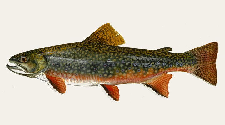
Brook troutExcellent

The best band: Vermont's ideal is 55-60Β°F. Fish feed in daylight, since Michigan DNR notes they are more diurnal than other trout, and in ponds and lakes Maine IFW says spring and fall bring them near shore and the surface.
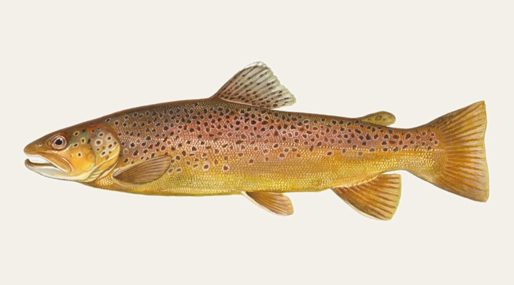
Brown troutExcellent

Close to Vermont's 53-66Β°F optimum, browns feed more freely; in fall, pre-spawn fish move toward tributaries and gravel, so fish streamers and keep off the redds.
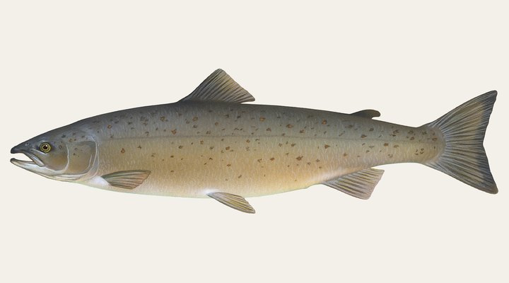
Landlocked salmonGood

Spring after ice-out and the fall cool-down are the surface seasons, with fish near shore and at stream mouths feeding on smelt: troll or cast streamers and smelt imitations.
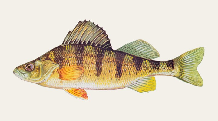
Yellow perchGood

Spring and fall: perch hold shallower and, by Michigan DNR's account, feed through the day, so shoreline weed edges, flats and the shallows near spawning areas are worth searching.

Tomorrow: Similar at 53 F. The solunar majors shift about 50 minutes later.Next report: Sat, Oct 24, 6:30 AMHow this report is made β†’

Before you go

Maine requires a fishing licence from age 16, from $30.00 for residents. What a Maine licence costs and where to buy it β†’

Chasing landlocked salmon here? Check the size and bag limits with MDIFW before you keep anything. The season dates for Maine, read off the agency, are on the Maine seasons page.

Water and weather

Live readings.

No live gauge on this water

Conditions here are modeled from weather, season and the nearest stations. Water readings appear when a USGS gauge is available.

304050607080JanMarMayJulSepNovOct, ~55 F now

Right now

Latest readings

Air temp42 F
High / Low49 / 31 F
WindN 9-17 mph
Pressure1027.3 hPa, rising
Sky / Rain1% cloud, 0%
Sunrise / Sunset07:09 / 17:44
MoonWaxing Gibbous, 91%
Water temp (seasonal)~55 F est.

Bite planner

Hour-by-hour bite forecast for today. Tap a bar to see why.

5 AM8 AM11 AM2 PM5 PM8 PMsunrisesunset

Which day to fish Mooselookmeguntic Lake this week

The best day on Mooselookmeguntic Lake this week looks like Sunday Oct 25, at 4 out of 5, against 2 today.

Best day this week: Sunday, Oct 25 β€” good at 4/5, falling pressure, usually the best window of a week.

Today, Oct 23 β€” Tough

Conditions favor short windows and patient fishing.

Solunar majors
9:16 AM-11:16 AM and 9:46 PM-11:46 PM
Minor period
3:38 AM-4:38 AM
Sun
07:09 to 17:44
Moon
Waxing Gibbous, 91% lit
Sky and wind
Overcast, 11 mph
Rain chance
0%

Forecast-based scores, less reliable further out: how the score is built.

Species guide

The species that matter on Mooselookmeguntic Lake: seasons, structure and how to fish each one. Today's ratings live in the report above.

Landlocked salmon illustration

Landlocked salmon

Spring and fall near the surface, deep in summer, and under the ice in winter

Landlocked salmon are Atlantic salmon that complete their whole life in fresh water, feeding mainly on rainbow smelt in cold lakes of Maine and the Northeast. Spring after ice-out and the fall cool-down are the surface seasons, with fish near shore and at stream mouths feeding on smelt: troll or cast streamers and smelt imitations.

Brook trout illustration

Brook trout

Spring and fall in ponds and lakes, when fish come shallow; summer in the coldest headwater streams

The brook trout is a char native to eastern North America, a fish of cold, clean streams and ponds, and the state fish of Michigan. The best band: Vermont's ideal is 55-60Β°F. Fish feed in daylight, since Michigan DNR notes they are more diurnal than other trout, and in ponds and lakes Maine IFW says spring and fall bring them near shore and the surface.

Yellow perch illustration

Yellow perch

Caught all year, including under the ice through winter

Yellow perch are schooling panfish of the Great Lakes and northern lakes, and Michigan DNR calls them the game fish most often caught in that state. Spring and fall: perch hold shallower and, by Michigan DNR's account, feed through the day, so shoreline weed edges, flats and the shallows near spawning areas are worth searching.

Brown trout illustration

Brown trout

Spring along Great Lakes shorelines; low light and overcast days in rivers; fall spawning runs

A European trout first stocked in the US in 1883 and now fished in rivers and lakes nationwide; it tolerates warmer water than other trout, and mature stream fish feed mostly at night. Close to Vermont's 53-66Β°F optimum, browns feed more freely; in fall, pre-spawn fish move toward tributaries and gravel, so fish streamers and keep off the redds.

When to come: the Mooselookmeguntic Lake calendar

Activity by species and month, and how the water warms through the year. Tap any cell.

Species activity by month

1 = slow, 5 = peak. Current month highlighted.

J
F
M
A
M
J
J
A
S
O
N
D
Landlocked salmon
Brook trout
Yellow perch
Brown trout
SlowPeak

Water temperature through the year

Typical surface temperature for this water type; today is around 55 F (estimated, not a reading).

304050607080JanMarMayJulSepNovOct, ~55 F now

Angler reports

Real reports from real anglers, reviewed before publishing. The water log below tracks each day automatically.

No angler reports yet this weekBe the first: your report helps every angler who checks Mooselookmeguntic Lake today, and we feature the best catch of the week.

Water log, last days

Auto-logged from live data
Thu, Oct 22

4/5 Good. Solid day ahead. Stable-to-falling pressure and workable wind line things up. Landlocked salmon led the card at excellent. High of 58 F, wind to 13 mph.

Wed, Oct 21

4/5 Good. Solid day ahead. Stable-to-falling pressure and workable wind line things up. Landlocked salmon led the card at excellent. High of 58 F, wind to 6 mph.

Tue, Oct 20

2/5 Slow. Work for them. Conditions favor short windows and patient fishing. Brook trout led the card at excellent. High of 58 F, wind to 12 mph.

Where roughly, what depth, what bait. Skip anything you want to keep secret.
Only used if we need to ask you about your report. No mailing list, no spam.

Before you go

License

Maine requires a valid fishing license for adults. Buy online from the state agency; one-day options exist for visitors.

Regulations

Maine fishing license. MDIFW special law for Mooselookmeguntic Lake (includes Cupsuptic Lake): closed to ice fishing; brook trout 2 a day, 10-inch minimum, only 1 over 12 inches; no size or bag limit on landlocked salmon under 16 inches and 1 a day over 16 inches; smelts by hook and line only, and direct tributaries closed to smelting. Upper Dam Pool and Bemis Stream have separate fly-fishing-only rules.

Access

MDIFW's lake survey map marks Haines Landing. Ramp details and fees are not on the MDIFW pages opened.

About this water

A 16,300-acre lake (MDIFW), 139 feet deep, joined with Cupsuptic Lake by the dam at Upper Dam; Franklin and Oxford counties, Maine.

Fishing Mooselookmeguntic Lake: the full guide

Two basins under one name

MDIFW's lake survey map explains that Mooselookmeguntic and Cupsuptic were separate lakes until a 20-foot dam at Upper Dam, the outlet, raised the water about 14 feet and joined them. MDIFW treats them as one water of 16,300 acres with a maximum depth of 139 feet (60 feet on average), spread across Rangeley and Rangeley Plantation in Franklin County and Richardsontown and Adamstown townships in Oxford County. The dam allows a drawdown of up to about 12 feet. MDIFW describes the water as excellent for coldwater fish, despite competition from yellow perch.

Wild salmon and native trout

MDIFW calls Mooselookmeguntic the largest of the Rangeley chain and manages it for wild landlocked salmon and brook trout. Brook trout are native to the drainage; salmon were introduced in 1875, and neither has been stocked since 1984. The Kennebago River, Cupsuptic River and Bemis Stream are the main spawning tributaries. Because salmon have grown slowly at high densities, MDIFW has loosened salmon rules to encourage harvest of smaller fish, while brook trout growth has stayed steady. Smelt are the main forage; a relict population of brown trout is rarely caught.

Upper Dam Pool

Upper Dam Pool, between the Mooselookmeguntic dam and a line between two cribwork piers about 800 yards west of it, has its own MDIFW rules: fly fishing only, one landlocked salmon a day with a 16-inch minimum, all brook trout released, and catch-and-release fly fishing in October. Below the pool, Upper Richardson Lake has separate regulations.

Common questions

Can I keep salmon on Mooselookmeguntic?

Yes. MDIFW sets no size or bag limit on landlocked salmon under 16 inches and allows one a day over 16 inches, to thin a dense, slow-growing salmon population.

Is Mooselookmeguntic open to ice fishing?

No. MDIFW's special law closes the lake, including Cupsuptic, to ice fishing.

What are the rules at Upper Dam Pool?

Fly fishing only, one landlocked salmon a day at 16 inches or longer, all brook trout released, and catch-and-release only in October, per MDIFW.

Is fishing good at Mooselookmeguntic Lake right now?

Check the daily report at the top of this page: it is regenerated every morning from live data. Today's read: Slow. Work for them. Conditions favor short windows and patient fishing.

Nearby waters

Where this page's numbers come from

Weather and pressure
Open-Meteo forecast model
Queried at 44.9200, -70.8000 in this water's own timezone. A model, not an observation.
Moon and solunar windows
Calculated on this site
Astronomical calculation from these coordinates and the date, not a third-party feed. How much weight it deserves.
Pages checked
The facts in the written guide were checked against these pages, from the agencies and operators that manage the water, on October 6, 2026. Anything we could not verify was taken out.
The written guide on this page
Pablo Ruiz Quintero
How this page was made. The daily report is computed by our scoring engine from live readings; nobody types it. The written text was drafted with AI assistance from the official pages listed above, and its facts were checked against those pages by automated verification on October 6, 2026; anything that could not be verified was taken out. Pablo Ruiz Quintero sets every guideline, the data-verification system and the minimum standards a page must meet to be published, reviews page structure and approves what goes live; the responsibility is his, and the AI carries out the work. We work this way because it is how one person can keep every page current with named sources. Errors are published in the verification log; the full policy is in the editorial policy.

Readings refresh on a 30-minute window. The full method, with every figure and its source, is on how our reports are made. Something wrong here? Tell us and it goes in the log with the date.