Greenwich Bay Fishing Report

Updated Mon, Nov 9, 2026 from live gauge and weather data

Greenwich Bay: a Warwick and East Greenwich estuary with coves, marinas and public rights-of-way to the shore.

2/5
Slow. Work for them.Conditions favor short windows and patient fishing.
Next tide
Low 12:58 PM
Air / High
46 / 54 F
Wind
W 9 mph

Sources: NOAA tides 8454578, Open-Meteo, solunar calculated for these coordinates.

Satellite view
Monday
9
November 2026

Today's Fishing Report

Generated this morning from live readings: gauge, weather model, sun and moon. A fresh report is published here every morning.

2/5Slow. Work for them.Conditions favor short windows and patient fishing.

Greenwich Bay rewards those who follow the bait as the water cools. Today brings clear skies, wind W around 9 mph, rising pressure near 1006 hPa and a high of 54. Tides: high 7:36 AM and 7:57 PM, low 12:13 AM and 12:58 PM: the moving water either side of each change is when this place feeds. Water sits around 55 F for the season (estimated). With the new moon, the solunar majors run 11:10 PM-1:10 AM and 10:46 AM-12:46 PM: the windows to build the day around.

The plan, species by species
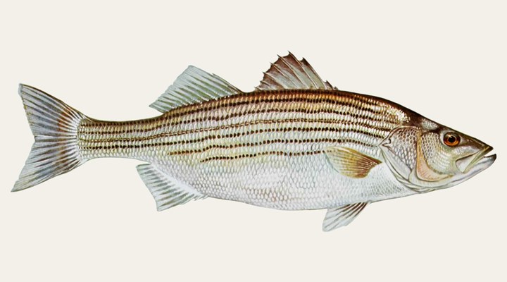
Striped bassGood

Spring and fall are the shoreline seasons: ODWC points to windblown points, riprap and dams during the May shad spawn and the pre-winter feed.
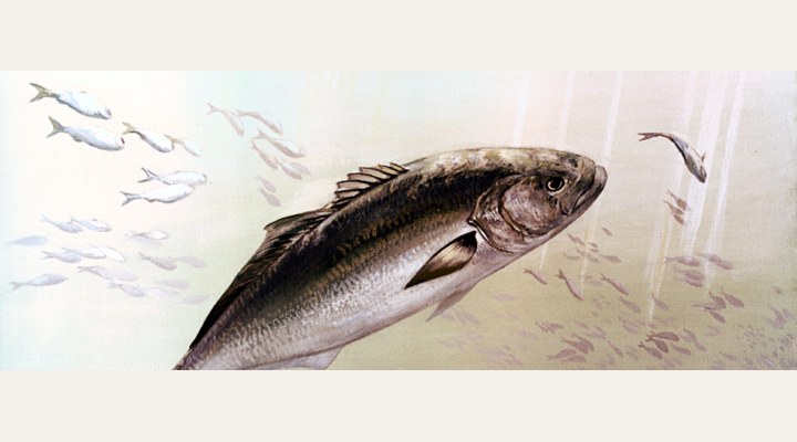
BluefishFair

Fall turns the migration south toward the South Atlantic Bight, and fish feed along beaches and inlets on the way. Follow the bait and the birds.

Tomorrow: Similar at 52 F. The solunar majors shift about 50 minutes later.Next report: Tue, Nov 10, 6:30 AMHow this report is made β†’

Before you go

Rhode Island requires a fishing licence from age 15, from $24.00 for residents, and salt water needs its own licence here. What a Rhode Island licence costs and where to buy it β†’

Chasing striped bass here? Check the size and bag limits with RI DEM before you keep anything. The season dates for Rhode Island, read off the agency, are on the Rhode Island seasons page.

Water and weather

Live readings.

Tides

NOAA station 8454578 (East Greenwich, Greenwich Bay). Fish the moving water either side of each change.

Mon
LOW12:13 AM0.1 ft
HIGH7:36 AM4.7 ft
LOW12:58 PM0.1 ft
HIGH7:57 PM3.9 ft
Tue
LOW12:53 AM0.1 ft
HIGH8:15 AM4.5 ft
LOW1:37 PM0.1 ft
HIGH8:36 PM3.8 ft

Bristol tide chart: the week and the month β†’

Right now

Latest readings

Air temp46 F
High / Low54 / 43 F
WindW 9-15 mph
Pressure1005.8 hPa, rising
Sky / Rain0% cloud, 13%
Sunrise / Sunset06:27 / 16:31
MoonNew Moon, 0%
Water temp (seasonal)~55 F est.

Bite planner

Hour-by-hour bite forecast for today. Tap a bar to see why.

5 AM8 AM11 AM2 PM5 PM8 PMsunrisesunset

Which day to fish Greenwich Bay this week

The best day on Greenwich Bay this week looks like Saturday Nov 14, at 4 out of 5, against 2 today.

Best day this week: Saturday, Nov 14 β€” good at 4/5, falling pressure, usually the best window of a week.

Today, Nov 9 β€” Tough

Conditions favor short windows and patient fishing.

Solunar majors
11:10 PM-1:10 AM and 10:46 AM-12:46 PM
Minor period
6:38 AM-7:38 AM
Sun
06:27 to 16:31
Moon
New Moon, 0% lit
Sky and wind
Overcast, 12 mph
Rain chance
13%

Forecast-based scores, less reliable further out: how the score is built.

Species guide

The species that matter on Greenwich Bay: seasons, structure and how to fish each one. Today's ratings live in the report above.

Striped bass illustration

Striped bass

Best: spring and fall inland; on the coast, during the seasonal migrations

The largest of the temperate basses, a sea-run fish of the Atlantic and Gulf coasts that now also lives in reservoirs across much of the country after hatchery stocking. Inland, it follows schools of shad and herring through open water. Spring and fall are the shoreline seasons: ODWC points to windblown points, riprap and dams during the May shad spawn and the pre-winter feed.

Bluefish illustration

Bluefish

Peak harvest: May-Oct, most in Jul-Aug (NOAA)

Bluefish (Pomatomus saltatrix) are sharp-toothed schooling predators that move up and down the Atlantic coast with the seasons and feed in surface blitzes on menhaden, silversides and squid. Fall turns the migration south toward the South Atlantic Bight, and fish feed along beaches and inlets on the way. Follow the bait and the birds.

When to come: the Greenwich Bay calendar

Activity by species and month, and how the water warms through the year. Tap any cell.

Species activity by month

1 = slow, 5 = peak. Current month highlighted.

J
F
M
A
M
J
J
A
S
O
N
D
Striped bass
Bluefish
SlowPeak

Water temperature through the year

Typical surface temperature for this water type; today is around 55 F (estimated, not a reading).

4050607080JanMarMayJulSepNovNov, ~55 F now

Angler reports

Real reports from real anglers, reviewed before publishing. The water log below tracks each day automatically.

No angler reports yet this weekBe the first: your report helps every angler who checks Greenwich Bay today, and we feature the best catch of the week.

Water log, last days

Auto-logged from live data
Sun, Nov 8

3/5 Fair. Fish the windows. A steady pattern: dawn and dusk carry the day. Striped bass led the card at good. High of 58 F, wind to 15 mph.

Sat, Nov 7

3/5 Fair. Fish the windows. A steady pattern: dawn and dusk carry the day. Striped bass led the card at good. High of 63 F, wind to 13 mph.

Fri, Nov 6

3/5 Fair. Fish the windows. A steady pattern: dawn and dusk carry the day. Striped bass led the card at good. High of 67 F, wind to 14 mph.

Where roughly, what depth, what bait. Skip anything you want to keep secret.
Only used if we need to ask you about your report. No mailing list, no spam.

Before you go

License

Rhode Island requires a valid fishing license for adults. Buy online from the state agency; one-day options exist for visitors.

Regulations

Rhode Island saltwater fishing requires a license or registration; size, possession and season rules are set by RI DEM Marine Fisheries. Check DEM's current recreational rules before keeping striped bass, bluefish, scup or flounder.

Access

CRMC-designated rights-of-way around the bay (guide published 2005), including the Long Street boat ramp on Water Street and the municipal ramp on Crompton Avenue in East Greenwich. Parking is limited or prohibited at many sites.

About this water

An estuary bordered by Warwick and East Greenwich, Kent County, Rhode Island, covered by a CRMC Special Area Management Plan.

Fishing Greenwich Bay: the full guide

An estuary under a management plan

Rhode Island's Coastal Resources Management Council describes Greenwich Bay as a productive estuary that provides shellfish habitat, shoreline access, boating and scenic views, and whose water quality is threatened by stormwater runoff, failing septic systems and over-development. The council prepared a Special Area Management Plan with Warwick, East Greenwich and other agencies to restore and balance uses of the bay.

Coves and rights-of-way

The council's guide to designated rights-of-way maps public access around Potowomut Neck, Greenwich Cove, the North Shore, and Warwick and Brushneck coves, with Apponaug and Buttonwoods coves also on the bay. In Greenwich Cove it describes the Long Street right-of-way on Water Street as a boat ramp marked with a public access sign, and notes a municipal boat ramp on Crompton Avenue. The guide was published in 2005 and warns that site conditions may change.

Tides

NOAA keeps a tide-prediction station named East Greenwich in the bay. Its nearest station with live water-level readings is Conimicut Light.

Common questions

Is there public shore access?

Yes. CRMC's guide lists designated rights-of-way around the bay, from Potowomut Neck and Greenwich Cove to Warwick and Brushneck coves; many have little or no parking.

Which tide station applies?

NOAA's East Greenwich prediction station is in the bay; Conimicut Light is the nearest station with live water levels.

Is fishing good at Greenwich Bay right now?

Check the daily report at the top of this page: it is regenerated every morning from live data. Today's read: Slow. Work for them. Conditions favor short windows and patient fishing.

Nearby waters

Where this page's numbers come from

Tide predictions
NOAA CO-OPS 8454578 β€” East Greenwich, Greenwich Bay
Harmonic predictions, datum MLLW, local time. 12 high and low events returned for today and the next two days. A prediction, not a measured water level: wind and surge move the real thing.
Weather and pressure
Open-Meteo forecast model
Queried at 41.6650, -71.4500 in this water's own timezone. A model, not an observation.
Moon and solunar windows
Calculated on this site
Astronomical calculation from these coordinates and the date, not a third-party feed. How much weight it deserves.
Pages checked
The facts in the written guide were checked against these pages, from the agencies and operators that manage the water, on October 7, 2026. Anything we could not verify was taken out.
The written guide on this page
Pablo Ruiz Quintero
How this page was made. The daily report is computed by our scoring engine from live readings; nobody types it. The written text was drafted with AI assistance from the official pages listed above, and its facts were checked against those pages by automated verification on October 7, 2026; anything that could not be verified was taken out. Pablo Ruiz Quintero sets every guideline, the data-verification system and the minimum standards a page must meet to be published, reviews page structure and approves what goes live; the responsibility is his, and the AI carries out the work. We work this way because it is how one person can keep every page current with named sources. Errors are published in the verification log; the full policy is in the editorial policy.

Readings refresh on a 30-minute window. The full method, with every figure and its source, is on how our reports are made. Something wrong here? Tell us and it goes in the log with the date.